Balearic Islands
| Balearic Islands Islas Baleares Illes Balears |
|||
|---|---|---|---|
| — Autonomous Community — | |||
|
|||
 |
|||
| Coordinates: | |||
| Country | |||
| Capital | Palma de Mallorca | ||
| Government | |||
| - President | Francesc Antich Oliver (PSIB-PSOE) |
||
| Area(1.0% of Spain; Ranked 17th) | |||
| - Total | 4,992 km2 (1,927.4 sq mi) | ||
| Population (2008) | |||
| - Total | 1,071,221 | ||
| - Density | 214.6/km2 (555.8/sq mi) | ||
| - Pop. rank | 14th | ||
| - Ethnic groups | 79.2% Spanish, 20.8% foreign nationals | ||
| ISO 3166-2 | IB | ||
| Official languages | Catalan and Spanish | ||
| Statute of Autonomy | March 1, 2007 | ||
| Parliament | Cortes Generales | ||
| Congress seats | 8 (of 350) | ||
| Senate seats | 6 (of 264) | ||
| Website | Govern de les Illes Balears | ||
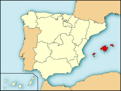
The Balearic Islands (Catalan and official:[1] Illes Balears IPA: [ˈiʎəz βəɫeˈas]; Spanish: Islas Baleares IPA: [ˈizlaz βaleˈaɾes]) are an archipelago in the western Mediterranean Sea, near the eastern coast of the Iberian Peninsula.
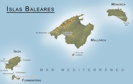
The four largest islands are (from largest to smallest): Majorca, Minorca, Ibiza, and Formentera. The archipelago forms an autonomous community and a province of Spain, of which the capital city is Palma. The co-official languages in the Balearic Islands are Spanish and Catalan (i.e. Mallorquí, Menorquí and Eivissenc, as Catalan is known by its speakers in this territory).
Contents |
Geography, politics and culture
The main islands of the autonomous community are Majorca (Mallorca), Minorca (Menorca), Ibiza (Eivissa) and Formentera, all of which are popular tourist destinations. Among the minor islands is Cabrera, which is the location of the Parc Nacional de l'Arxipèlag de Cabrera. The islands can be further grouped, with Majorca, Minorca, and Cabrera as the Gymnesian Islands, and Ibiza and Formentera as the Pine Islands.
Etymology
The Balearic islands (pronounced /bælɪˈærɨk ˈaɪləndz/) have two names in different languages: Catalan: Illes Balears, pronounced [ˈiʎəz bəɫeˈaː(r)s]; Spanish: Islas Baleares, [ˈislaz βaleˈaɾes]; Greek: Gymnesiae Γυμνησίαι and Balliareis Βαλλιαρεῖς;[2] Latin: Baleares.
There are various theories on the origins of the two ancient Greek and Latin names for the islands – Gymnasiae and Baleares. Two survive in classical sources.
According to the Lycophron's Alexandra verses, the islands were called Gymnesiae (gymnos - γυμνός means naked in Greek) because its inhabitants were often nude, probably because of the year-long benevolent climate.
The Greek and Roman writers generally derive the name of the people from their skill as slingers (baleareis, βαλεαρεῖς, from ballo, βάλλω:ancient Greek meaning for to launch), although Strabo considered the name to be of Phoenician origin. He observed that it was the Phoenician equivalent for the Greek word for lightly-armoured soldiers (γυμνῆτας) (gymnetas).[3]
The root bal does point to a Phoenician origin; perhaps the islands were sacred to the god Baal; and the accidental resemblance to the Greek root ΒΑΛ (in βάλλω - ballo), coupled with the occupation of the people, would be quite a sufficient foundation for the usual Greek practice of assimilating the name to their own language. That it was not, however, Greek at first, may be inferred with great probability from the fact that the common Greek name of the islands is not Βαλεαρεῖς (Baleareis), but Γυμνησίαι (Gymnesiai), the former being the name used by the natives, as well as by the Carthaginians and Romans.[4] The latter name, of which two fancied etymologies have been already referred to, is probably derived from the light equipment of the Balearic troops (γυμνῆται- gymnetae).[3]
History
Ancient history
There is little history on the earliest inhabitants of the islands, though many legends exist. The story, preserved by Lycophron, that certain shipwrecked Boeotians were cast nude on the islands, was evidently invented to account for the name Gymnesiae. There is also a tradition that the islands were colonized from Rhodes after the Trojan war.[3]
The islands had a very mixed population, of whose name of the islands (an instance of folk etymology) — until the Phoenicians clothed them with broad-bordered tunics. In other stories they were naked only in the heat of summer.
Other legends hold that the inhabitants lived in hollow rocks and artificial caves, that they were remarkable for their love of women and would give three or four men as the ransom for one woman, that they had no gold or silver coin, and forbade the importation of the precious metals, so that those of them who served as mercenaries took their pay in wine and women instead of money. Their marriage and funeral customs, peculiar to Roman observers, are related by Diodorus Siculus (v. 18).

In ancient times, the islanders of the Gymnesian Islands constructed talayots, and were famous for their skill with the sling. As slingers they served, as mercenaries, first under the Carthaginians, and afterwards under the Romans. They went into battle ungirt, with only a small buckler, and a javelin burnt at the end, and in some cases tipped with a small iron point; but their effective weapons were their slings, of which each man carried three, wound round his head (Strabo p. 168; Eustath.), or, as seen in other sources, one round the head, one round the body, and one in the hand. (Diodorus) The three slings were of different lengths, for stones of different sizes; the largest they hurled with as much force as if it were flung from a catapult; and they seldom missed their mark. To this exercise they were trained from infancy, in order to earn their livelihood as mercenary soldiers. It is said that the mothers allowed their children to eat bread only when they had struck it off a post with the sling.[5]
The Phoenicians took possession of the islands in very early times;[6] a remarkable trace of their colonization is preserved in the town of Mago (Mahon in Minorca). After the fall of Carthage, the islands seem to have been virtually independent. Notwithstanding their celebrity in war, the people were generally very quiet and inoffensive.[7] The Romans, however, easily found a pretext for charging them with complicity with the Mediterranean pirates, and they were conquered by Q. Caecilius Metellus, thence surnamed Balearicus, in 123 BC.[8] Metellus settled 3,000 Roman and Spanish colonists on the larger island, and founded the cities of Palma and Pollentia.[9] The islands belonged, under the Roman Empire, to the conventus of Carthago Nova (modern Cartagena), in the province of Hispania Tarraconensis, of which province they formed, the fourth district, under the government of a praefectus pro legato. An inscription of the time of Nero mentions the PRAEF. PRAE LEGATO INSULAR. BALIARUM. (Orelli, No. 732, who, with Muratori, reads pro for prae.) They were afterwards made a separate province, probably in the division of the empire under Constantine.[10]
The two largest islands (the Balearic Islands, in their historical sense) had numerous excellent harbours, though rocky at their mouth, and requiring care in entering them (Strabo, Eustath.; Port Mahon is one of the finest harbours in the world). Both were extremely fertile in all produce, except wine and olive oil.[11] They were celebrated for their cattle, especially for the mules of the lesser island; they had an immense number of rabbits, and were free from all venomous reptiles.[12] Among the snails valued by the Romans as a diet, was a species from the Balearic isles, called cavaticae, from their being bred in caves.[13] Their chief mineral product was the red earth, called sinope, which was used by painters.[14] Their resin and pitch are mentioned by Dioscorides[15] The population of the two islands is stated by Diodorus at 30,000.
The part of the Mediterranean east of Spain, around the Balearic Isles, was called "Mare Balearicum",[16] or "Sinus Balearicus".[17]
Post Roman Empire and Aragonese conquest
In the chaos surrounding the fall of the Roman Empire, the islands were conquered by the Vandals. They were subsequently reconquered by the Byzantine Empire, but soon fell to the Moors after the their conquest of Iberia. The emirate of Cordoba captured them in 903. After its dissolution, they depended from the taifa of Dénia (1013–1067), later becoming an independent taifa.
Between 1113 and 1115, a fleet, led by Ugo da Parlascio Ebriaco and Archbishop Pietro Moriconi of the Republic of Pisa, made a successful expedition against the Balearic Islands. The expedition was launched with the support of Constantine I of Logudoro and his base of Porto Torres.
In the 13th century (1239), king James I of Aragon conquered the islands, annexing them to the Crown of Aragon. After his death, he gave the Balearic islands (and other counties as Roussillon or Montpellier) as a new kingdom, the Kingdom of Mallorca, to his son James II. However, according to this king's will, even though his son would gain the title of King, he and his descendants were always to be vassals to the king of Aragon. In this case, this would mean James would be a vassal of Peter, the oldest son of James I. However, after a turbulent and difficult period of existence, the Kingdom of Mallorca was definitely reincorporated into the Crown of Aragon with the Battle of Llucmajor (1349).
In 1476, Ferdinand II (king of Aragon) and Isabella I (queen of Castile) were married. And, as a result to their death, their respective territories (until then governed separately) were governed jointly, in the person of his grandson: Charles V. This can be considered the foundation of the modern Spanish state, albeit a decentralized one where the various component territories within the two uniting crowns retained the historic laws and privileges.
The Balearic Islands were frequently attacked by Barbary pirates from North Africa, the Formentera was even temporarily left by its population. In 1514, 1515 and 1521 coasts of the Balearic Islands and the Spanish mainland were raided by Turkish privateer and Ottoman admiral Hayreddin Barbarossa.
The island of Minorca was a British dependency for most of the 18th century as a result of the Treaty of Utrecht. This treaty, signed by the Kingdom of Great Britain and the Kingdom of Portugal as well as the Kingdom of Spain to end the conflict caused by the War of the Spanish Succession, gave Gibraltar and Minorca to the Kingdom of Great Britain, Sardinia to Austria (both territories were part of the Crown of Aragon for over almost 5 centuries), and Sicily to the House of Savoy. In addition, Flanders and other European territories of the Spanish Crown were given to Austria.
Minorca was finally returned to Spain by the Treaty of Amiens during the French Revolutionary Wars, following the last British occupation, which lasted from 1798 to 1802.

See also
- Balearic cuisine
- List of municipalities in the Balearic Islands
- Gymnesian Islands
- Pine Islands
- Majorca
- Minorca
- Ibiza
- Isla de S'Espalmador
- Formentera
- Battle of Mallorca
- List of butterflies of Menorca
References
- ↑ Ley 3/1986, de 19 de abril, de normalización linguística. Ley 13/1997, de 25 de abril, por la que pasa a denominarse oficialmente Illes Balears la Provincia de Baleares. Ley Orgánica 1/2007, de 28 de febrero, de reforma del Estatuto de Autonomía de las Illes Balears.
- ↑ Diod. v. 17, Eustath. ad Dion. 457; Baliareis - Βαλιαρεῖς, Baliarides - Βαλιαρίδες, Steph. B.; Balearides - Βαλεαρίδες, Strabo; Balliarides - Βαλλιαρίδες, Ptol. ii. 6. § 78; Baleariae - Βαλεαρίαι Agathem.
- ↑ 3.0 3.1 3.2 Strab. xiv. p. 654; Plin. l. c "The Rhodians, like the Baleares, were celebrated slingers"
Sil. Ital. iii. 364, 365: "Jam cui Tlepolemus sator, et cui Lindus origo, Funda bella ferens Balearis et alite plumbo." - ↑ Plin.; Agathem.; Dion Cass. ap. Tzetz. ad Lycophr. 533; Eustath.
- ↑ Strabo; Diod.; Flor. iii. 8; Tzetzes ad Lycophron.
- ↑ Strabo iii. pp. 167, 168.
- ↑ Strabo; but Florus gives them a worse character, iii. 8.
- ↑ Livy Epit. Ix.; Freinsh. Supp. lx. 37; Florus, Strabo ll. cc.
- ↑ Strabo, Pomponius Mela, Pliny the Elder.
- ↑ Notitia Dignitatum Occid. c. xx. vol. ii. p. 466, Böcking.
- ↑ Aristot. de Mir. Ausc. 89; Diodorus, but Pliny praises their wine as well as their corn, xiv. 6. s. 8, xviii. 7. s. 12: the two writers are speaking, in fact, of different periods.
- ↑ Strabo, Mela; Pliny l. c., viii. 58. s. 83, xxxv. 19. s. 59; Varro, R. R. iii. 12; Aelian, H. A. xiii. 15; Gaius Julius Solinus 26.
- ↑ Pliny xxx. 6. s. 15.
- ↑ Pliny xxxv. 6. s. 13; Vitruv. vii. 7.
- ↑ Materia Medica i. 92.
- ↑ τὸ Βαλλεαρικὸν πέλαγος, Ptol. ii 4. § 3.
- ↑ Flor. iii. 6. § 9.
- This article incorporates text from the public domain Dictionary of Greek and Roman Geography by William Smith (1856).
External links
- Baleares.com Site
- Government of the Balearic Islands
- Spatial Information Infrastructure of Balearic Islands (IDEIB)
- www.in2menorca.com - guide for independent travellers
- Illes Balears - Official travel website for the Balearic Islands
- BalearesWeb - Website directory for the Balearic Islands
- Baleares Travel Net - Travel website directory in the Balearics
- SpainInfo - Touristic information of the Balearic Islands
- Balearic Islands Tourist Information
- Ibiza Map - Maps of the Balearic Island of Eivissa
- Minorcan history at the Consell Insular de Menorca's web page
- Travel guide to the Balearic Islands
- Resorts transfers from Airport
- Travel Guide - Balearic Tourist Guide
|
|||||||||||||||||||||||||||||||||||||||
|
|||||||||||||
|
|||||||
| Western Empire (395–476) | |||
|---|---|---|---|
| Praetorian Prefecture of Gaul |
Diocese of Gaul: Alpes Poeninae et Graiae • Belgica I • Belgica II • Germania I • Germania II • Lugdunensis I • Lugdunensis II • Lugdunensis III • Lugdunensis IV • Maxima Sequanorum Diocese of Vienne (later Septem Provinciae): Alpes Maritimae • Aquitanica I • Aquitanica II • Narbonensis I • Narbonensis II • Novempopulania • Viennensis Diocese of Spain: Baetica • Baleares • Carthaginensis • Gallaecia • Lusitania • Mauretania Tingitana • Tarraconensis Diocese of Britain: Britannia I • Britannia II • Flavia Caesariensis • Maxima Caesariensis • Valentia (369) |
||
| Praetorian Prefecture of Italy |
Diocese of Suburbicarian Italy: Apulia et Calabria • Bruttia et Lucania • Campania • Corsica • Picenum Suburbicarium • Samnium • Sardinia • Sicilia • Tuscania et Umbria • Valeria Diocese of Annonarian Italy: Alpes Cottiae • Flaminia et Picenum Annonarium • Liguria et Aemilia • Raetia I • Raetia II • Venetia et Istria Diocese of Africa†: Africa proconsularis (Zeugitana) | Byzacena • Mauretania Caesariensis • Mauretania Sitifensis • Numidia Cirtensis • Numidia Militiana • Tripolitania Diocese of Pannonia (later of Illyricum): Dalmatia • Noricum mediterraneum • Noricum ripense • Pannonia I • Pannonia II • Savia • Valeria ripensis |
||
| Eastern Empire (395–ca. 640) | |||
| Praetorian Prefecture of Illyricum |
Diocese of Dacia: Dacia Mediterranea • Dacia Ripensis • Dardania • Moesia I • Praevalitana Diocese of Macedonia: Achaea • Creta • Epirus nova| Epirus vetus | Macedonia I • Macedonia II Salutaris • Thessalia |
||
| Praetorian Prefecture of the East |
Diocese of Thrace: Europa • Haemimontus • Moesia II§ • Rhodope • Scythia§ • Thracia Diocese of Asia*: Asia • Caria§ • Hellespontus • Insulae§ • Lycaonia (370) • Lycia • Lydia • Pamphylia • Pisidia • Phrygia Pacatiana • Phrygia Salutaria Diocese of Pontus*: Armenia I* • Armenia II* • Armenia Maior* • Armenian Satrapies* • Armenia III (536) • Armenia IV (536) • Bithynia • Cappadocia I* • Cappadocia II* • Galatia I* • Galatia II Salutaris* • Helenopontus* • Honorias* • Paphlagonia* • Pontus Polemoniacus* Diocese of the East: Arabia • Cilicia I • Cilicia II • Cyprus§ • Euphratensis • Isauria • Mesopotamia • Osroene • Palaestina I • Palaestina II • Palaestina III Salutaris • Phoenice • Phoenice Libanensis • Syria I • Syria II Salutaris • Theodorias (528) Diocese of Egypt: Aegyptus I • Aegyptus II • Arcadia • Augustamnica I • Augustamnica II • Libya Superior • Libya Inferior • Thebais Superior • Thebais Inferior |
||
| Other territories | Taurica • Lazica (532/562) • Spania (552) | ||
| Notes | Provincial administration reformed by Diocletian, ca. 293. Praetorian prefectures established after the death of Constantine I. Empire permanently partitioned after 395. Exarchates of Ravenna and Africa established after 584. After massive territorial loss due to the Muslim conquests, the remaining provinces were superseded by the theme system in ca. 640–660, although they survived under the latter until the early 9th century * affected (boundaries modified/abolished/renamed) by Justinian's administrative reorganization in 534–536 † re-established after reconquest by the Eastern Empire in 534, as the separate praetorian prefecture of Africa § joined together into the Quaestura exercitus in 536 |
||

